SeekrGEO: Remote Sensing & Geospatial Intelligence
Transform multimodal, remote sensing data into intelligence with Seekr’s next-generation vision language foundation model
Request a demo
Limitations of traditional computer vision
Satellite imagery produces massive, complex datasets that outpace human analysts and conventional object detection tools—true intelligence demands explainability and reasoning. Traditional computer vision applications are designed for predictive tasks and lack the deeper capabilities required to make remote sensing actionable for human analysts.
Seekr fuses multisource, multimodal satellite and sensor data with next‑gen Visual Language Models, enabling rapid deployment of explainable, agentic AI that transforms massive imagery datasets into actionable intelligence at scale.
Reactive
Based on image comparison and pre-defined labeling and classification
Manual
Relies on manually labeled training datasets of image-label pairs on specific tasks. These are not readily available for certain types of data (e.g., LiDAR)
Limited
Human analysts cannot keep up with increasing volumes of satellite imagery, and traditional tools are only trained for predictive tasks, such as Object Detection and Anomaly Detection
The Seekr Difference
Multi-modal understanding
Seamless fusion and geospatial understanding of multiple remote sensing modalities, including LiDAR, SAR, RADAR, multispectral/hyperspectral, optical, and infrared.
Full explainability
Full reasoning capabilities so humans can ask questions to understand imagery, land usage classification, change detection, and plan/simulate course of actions.
Fit-for-purpose
Unlike traditional models that flatten images into 2D, Seekr preserves 3D versions optimized for every environment and use case.
Edge-optimized
Rapid training and distillation of edge-optimized models close to the location of data capture, including at the tactical edge.
Automated data preparation
Automatically labels datasets to lower costs and enable faster processing of more imagery.
How it works
Seekr brings its full SeekrFlow AI Factory, foundation model building expertise, and edge deployment capabilities to national security and defense agencies analyzing geospatial intelligence.
Complete AI Factory
SeekrFlow is the most efficient way to build, operate, and monitor AI applications like Actionable Remote Sensing on any infrastructure—even at the tactical edge.
Geospatial expertise
Purpose-built Visual Language Models (VLMs) fuse EO, IR, SAR, LiDAR, and hyperspectral data for national security and defense use cases.
Model flexibility
With models from 1B to 13B parameters, Seekr delivers the right balance of speed, efficiency, and accuracy for diverse mission demands.
Rapid deployment
The SeekrFlow AI Factory and Edge Platform enable fast integration and rollout of agentic AI applications—so intelligence reaches the field when it’s needed most.
Use cases
Seekr supports the most advanced use cases:
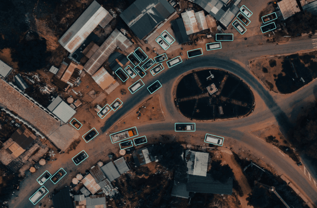
Fine-grained object detection & recognition
Object tracking
Change detection & explanation
Scene explanation
Pattern of life analysis
Event monitoring & alerting
Infrastructure construction
Monitoring
Land use classification
Disaster assessment
Automated data labeling
Pattern & anomaly detection
Enemy order of battle
Explore more solutions
View all solutions

SeekrGuard: AI Evaluation & Certification
Evaluate and vet LLMs and AI applications for bias, accuracy, and risks to ensure trust and transparency.

SeekrScribe: Accelerated Procurement & Solicitations
Shrink procurement, proposal, and vendor evaluation time from months to minutes.

Customer & Citizen Services
Engage customers and citizens in natural, scalable ways—powered by your data.